Wetlands have been defined in different ways by numerous entities and agencies, however, the United States Army Corps of Engineers (Corps) and the United States Environmental Protection Agency (EPA) jointly define wetlands as: “Those areas that are inundated or saturated by surface or groundwater at a frequency and duration sufficient to support, and that do under normal circumstances support, a prevalence of vegetation typically adapted for life in saturated soil conditions. Wetlands generally include swamps, marshes, bogs, and similar areas.” This definition of wetlands is perhaps the most relevant to local land planners because the Corps and the EPA are the agencies that have legal jurisdiction over wetlands, including those wetlands on private property. Wetlands provide numerous benefits to society but a few of the most important of these include wildlife habitat area, hydrologic recharge areas, and water quality improvements. Other values like recreation (e.g. hunting, fishing, or bird watching) are a combination of processes.[1]
Related resource topics for county planning include:
According to the Utah Wetland Information Center, 1% of Utah’s landscape is wetlands[2], however, over 75% of the State’s wetlands occur along the northern and eastern shorelines of the Great Salt Lake.[3]
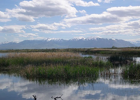
Wetlands are among the most productive ecosystems in the world, comparable to rainforests and coral reefs.[4] They provide habitat for different species including birds and fish. Wetlands also have the ability to improve water quality by acting as filters. In addition, wetlands can lessen the effects of flooding by storing water and releasing it slowly with the potential to help replenish aquifers.
“Wetland” is a generic term used to describe a diverse array of aquatic habitats.[5] To assist in management and inventory purposes the Cowardin hierarchical classification system is most commonly used. This method classifies wetlands into systems, subsystems, and classes. Systems are divided into marine, estuarine, riverine, lacustrine, and palustrine. Marine and estuarine systems consist of open ocean and tidal areas, respectively. Riverine and lacustrine systems include wetlands adjacent to rivers and lakes, respectively. Lastly, palustrine systems include vegetated wetlands like marshes, swamps, bogs, and small ponds.[6] Forested wetlands can occur in the estuarine and palustrine systems only.The Cowardin system is used by the US Fish and Wildlife Service (USFWS) for their National Wetlands Inventory (NWI). The NWI Wetland data can be used to identify wetlands by type within the county.
From a regulatory standpoint, certain bodies of water and associated wetlands are regulated by the US Environmental Protection Agency (EPA) and the US Army Corps of Engineers (Corps) under Section 404 of the Clean Water Act (CWA). Activities which involve excavation or placement of fill in jurisdictional waters or wetlands require a permit issued by the Corps and may be reviewed by EPA. The extent of jurisdiction is determined on a project-by-project basis in consultation with the Corps.
As discussed previously, wetlands provide numerous benefits to society. Proper management and protection of wetlands can improve the quality of life for local communities. Best management practices (BMPs) can include but are not limited to:
- Protection of existing wetlands,
- Restoration of historic wetlands that have been eliminated or degraded,
- Proper management of wetlands,
- Creation of additional wetlands in appropriate areas.
Additional best management practices for wetlands include educating the public on the importance of wetlands, educate farmers and developers on the property value improvements provided by managed open spaces including wetlands, develop assessment tools to monitor the condition of existing wetlands, and develop land management partnerships that include landowners.
The EPA provides information on wetland protection and restoration. This information includes potential funding sources for eligible applicants.
The Natural Resource Conservation Service (NRCS) provides landowners financial and technical assistance to restore, enhance, and protect wetlands through their Agricultural Conservation Easement Program (ACEP).
The North American Wetland Conservation Act (NAWCA) provides matching grants to support bird populations and wetland habitat.
The Utah Division of Water Quality Wetland Program offers standard procedures for managing, and evaluating the condition of wetlands in the Great Salt Lake area.
The Utah Wetlands Interpretive Network Sites (UWIN) provide wetlands education and refer visitors to other sites within a 13 sites network. More than half of these sites are located in the Wasatch Front area.
- Possibly the most significant economic and social benefit of wetlands is flood control, but wetlands also provide essential functions in filtering water/improving water quality and providing a food source for waterfowl.[7] Furthermore, wetlands recharge aquifers and thereby secure future water supplies.
- A report regarding the Economic Significance of the Great Salt Lake to the State of Utah, includes information regarding benefits of wetlands surrounding the lake.[8]
- Under the North American Wetlands Conservation Act (NAWCA), 10 Utah projects are funded through $3.7 million from NAWCA and $11 million from partner contributions; this illustrates a successful public-private partnership approach to conserve wetlands.[9]
Mechanisms for wetland protection include acquisition, planning, mitigation, disincentives for conversion of wetlands to other land uses, among other efforts. Human need for development should be an important factor when considering wetland restoration or creation.[10]
Noxious weeds, and pest control are other factors to be considered in wetland management, especially when close to residential areas.
In addition, other resources like agriculture, water rights, and hydrology may cause changes to wetlands and should be considering when managing them. For example, groundwater development can reduce the amount of water that a wetland receives.[11] Changes in stormwater, diversions, or water uses from adjacent farms can also create or destroy wetlands.
| Data Name | Data Explanation | Publication Date | Spatial Accuracy | Contact |
|---|---|---|---|---|
| Localized Wetland Mapping , | Provides generalized wetland location maps | Updated October 1, 2015 | Approximate range 1:145,000-1:1,2000 | US Fish and Wildlife Service’s National Wetland Inventory |
| National Wetlands Inventory (NWI) (AGRC) , (USFWS) , | Use to identify location and type of wetlands Metadata | USFWS data download 10/2015; USGS web mapper is live data; Map Service date is 10/2015. | 1:50,000 | Primary Source: Utah Geological Survey or US Fish and Wildlife Service’s National Wetland Inventory AGRC data provider Utah Geological Survey |
References
- Novitzki, R., D. Smith, and J. Fretwell. 1996. Wetland Functions, Values, And Assessment. National Water Summary On Wetland Resources. Washington, D.C.: US Government Printing Office.
- Utah Department of Natural Resources, Utah Geological Survey. 2015. “Wetland Outreach and Education.” Accessed: 1/6/16.
- Utah Department of Natural Resources, Division of Wildlife Resources, Utah Wildlife Action Plan Joint Team. 2015. Utah Wildlife Action Plan: A plan for managing native wildlife species and their habitats to help prevent listing under the Endangered Species Act. Publication number 15-14. Salt Lake City, Utah, USA.
- US Environmental Protection Agency. 2015. “What Are Wetland Functions?” Accessed: 1/6/16.
- Tiner, R. 1996. Wetland Definitions and Classifications in the United States. National Water Summary On Wetland Resources. Washington, D.C.: US Government Printing Office.
- Cowardin, L., V. Carter, F. Golet, and E. LaRoe. 1979. Classification of wetlands and deepwater habitats of the United States. Washington, D.C.: U.S. Government Printing Office.
- World Wildlife Fund. 2004. The Economic Values of the World’s Wetlands, January.
- Bioeconomics, Inc. 2012. Economic Significance of the Great Salt Lake to the State of Utah. Report prepared for the Great Salt Lake Advisory Council, January 26.
- Ducks Unlimited. 2013. The North American Wetlands Conservation Act: Working for Utah.
- Kentula, M. 1996. Wetland Restoration and Creation. National Water Summary On Wetland Resources. Washington, D.C.: US Government Printing Office.
- Bishop, C.E., M. Lowe, J. Wallace, R.L. Emerson and J.S. Horn. 2009. Wetlands in the Farmington Bay area, Davis County, Utah-An evaluation of threats posed by ground-water development and drought. Utah Geological Survey, Report of Investigation 264.